"Precautionary" state of emergency declared

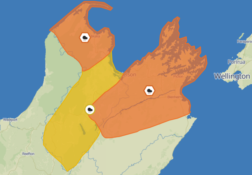
Marlborough now sits only under a orange rain warning, however that may bring over a month's worth of rain over the next 24 hours. Photo: MetService
Some Spring Creek residents have been notified to evacuate before 6am tomorrow morning, as Marlborough remains under a Rain Warning until Friday afternoon which could deliver over a month of usual rainfall.
Mayor Nadine Taylor declared a local state of emergency for part of Marlborough at 5pm today, to facilitate the precautionary evacuation of Spring Creek and in case of any other flooding issues overnight and tomorrow.
The 9pm MetService update said Nelson District about and southeast of SH 6 and north of Nelson Lakes, and Marlborough about and north of Seddon to expect 100 to 150 mm of rain on top of what has fallen and peak rates of 20 to 30 mm/h or possibly more -
Previous strong wind warnings have now passed for the region.
A Civil Defence Centre providing community support and information will open at Stadium 2000 in Blenheim from 9am tomorrow. Tuamātene Marae at 2518 State Highway 1, Grovetown will also be open at 7am tomorrow, where hot drinks and kai will be available.
Residents of Dodson, Hathaway, and March streets, as well as part of Ferry Road in Spring Creek township have been advised to evacuate their homes by 6am Friday morning due to the compromised Wairau River stop bank in the area.
This evening, Civil Defence and emergency services staff went door-to-door in the township to inform residents of the evacuation advice.
Residents are encouraged to stay with friends and family as their first port of call.
Staff from Council’s Rivers (flood protection) team will monitor the Wairau River overnight.
MetService meteorologists reaffirmed the orange Heavy Rain Warning at 9pm Thursday evening until 6pm Friday.
At as of 9pm, the heaviest rain was in western parts of Marlborough and moving south easterly.
Marlborough Emergency Management Controller Richard MacNamara said tonight's rainfall was a dynamic event, and "all of Marlborough’s emergency and lifelines agencies are up to speed and our response teams are ready to go".
While the rain forecast remains somewhat uncertain, the weather system does have the potential to stall and deliver additional rainfall on Friday.”
“With the Wairau River stop bank at Spring Creek in a compromised state awaiting upgrads, we are taking the precaution of advising residents of Spring Creek township to plan to evacuate their homes from 6am Friday, tomorrow morning.
"They can leave this evening if they wish but the key time when the river may be running high is from early tomorrow morning.”
“Spring Creek residents are asked to stay with family or friends - have a grab bag ready and take pets and prescription medications with them".
MetService Meteorologist Lewis Ferris said earlier today that even if predictions don't reach their forecasted maximum, the next two days "is not a small amount of rain for the region so people should expect rain related impacts.
"Generally, the rain has set in around the top of the South and looks to persist through to Friday evening.
"Blenheim itself could get 100-130mm of rain - the month of June typically sees the town get around 70mm.
"Larger amounts of rain will be falling in the ranges, and this has to go somewhere so be wary of rising rivers around the region".
Sign up to Antenno here: https://www.marlborough.govt.nz/services/apps/antenno.
Keep an eye on MetService for watch and warning updates at www.metservice.com/warnings/home
NZ Transport Agency are urging drivers to be ready for bad weather driving conditions on the region’s roads. Read the latest update at: www.journeys.nzta.govt.nz/traffic-bulletins/wet-and-windy-weather-on-the-way-for-top-of-the-south-drivers
Remember, it is always important to be prepared. For further information on emergency preparedness go to: https://getready.govt.nz/emergency/floods