Officials offer guidance on navigating SH1
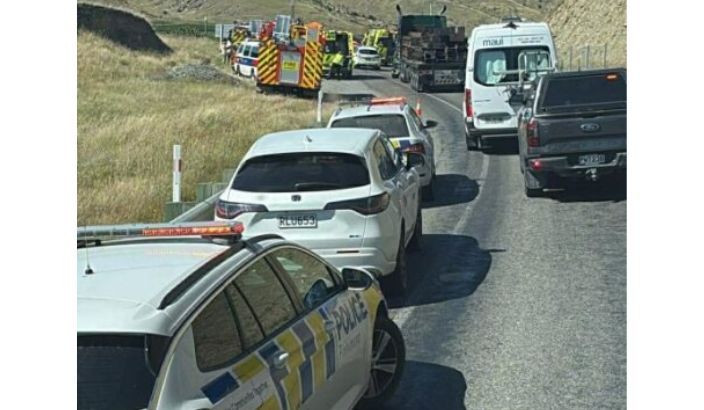
Traffic backs up on SH1 near Redwood Pass as police and emergency personnel respond to a crash in Marlborough on February 22. The two-vehicle collision killed three, seriously injured two, and closed the road for six hours. Photo: Supplied.
Between Riverlands and Kaikoura, SH1 features breathtaking views as it weaves among inclines and along the coastline. It strikes awe, but it also strikes fear.
Two serious crashes last month took lives, with one closing SH1 for six hours on a Sunday.
Steering clear of danger demands attention. To help Marlburians and visitors, Marlborough Weekly asked police and roads officials for guidance.
Driving on SH1
Marlborough presents circumstances common to – but also distinct from – other parts of the country.
Inspector Martin Tunley, Tasman District Road Policing Manager, notes “factors that we know contribute to death and serious injury on our roads, everywhere in New Zealand” are speed, impairment – “including fatigue and distraction” – and not using seatbelts or restraints.
The local region, situated within NZ Police’s Tasman District, draws a confluence of people heading northbound from South Island spots and southbound from North Island spots.
“We know travellers heading north for the Cook Strait ferries could potentially be susceptible to fatigue, as often they have travelled long distances, and when getting closer to the terminal, may choose to keep driving instead of taking a break,” the inspector stated. “We urge anyone in this position to think again – a quick stop to rest your eyes, swap drivers, or grab refreshments might make all the difference.
“Tasman District is the first South Island stop for people getting off the ferry, and unfamiliarity with the South Island roads may be a factor,” he continued. “We urge anyone travelling around our district to pay close attention to the roads, particularly if you’re not familiar with the area.”
Advice that applies anywhere, anytime: “Put your phone away, watch your speed, and make sure everyone’s buckled up.”
Heading off SH1
Traffic jams, whether from an incident or congestion, prompt drivers with less time than patience to head off the road. They may rely on personal knowledge or a mapping app to find a way around. Either way, haste can make time waste.
First, some food for thought from Marlborough Roads System Manager Wayne Oldfield: There are no detours or alternate routes, only roads. Every road has characteristics – distance, paving, grade, turns, weather resilience – that influence decisions to take it.
Redwood Pass and Taylor Pass may make sense for cars and utes, given that heavy trucks cannot use them. Then again, an influx of vehicles or a burst of torrential rain could bog down these roads just as easily.
Taking other highways – SH63 or SH7, with SH65 as linkage – makes for greater distance but also the prospect of a smoother ride.
“[Drivers] will go where they want to go,” the roads manager said, “but they have to take a bit of responsibility and make sure they’re able to drive those roads.”