Sat, Jul 17, 2021 10:19 AM
Tuamarina, Spring Creek evacuated as flood bank breached


Matt Brown
All of Tuamarina township near Blenheim has been advised to evacuate due to a breached stop bank.
This follows earlier evacuations in Spring Creek, Renwick and part of the Lower Wairau near Blenheim.
About 270 people live in 99 properties in Tuamarina.
They are advised to seek accommodation in the Blenheim area with family or friends.
If you have nowhere to go, please call council on (03) 520 7400 or go to Stadium 2000 in Kinross St, Blenheim where an information centre is being set up.
Evacuees will be allowed to cross the Wairau River bridge on SH1. Only south-bound traffic will be allowed to cross.
All of Spring Creek township near Blenheim was advised to evacuate at about 4.45pm following earlier evacuations in part of the Lower Wairau near Blenheim.
About 430 people live at 162 properties in Spring Creek.
They are advised to seek accommodation in the Blenheim area with family or friends. If you have nowhere to go, call council on 03 520 7400.
The affected area is Neal Road bridge to Chaytors, Connolly’s and Wairau Bar roads. The only access point now is via Neal Road bridge, into Rarangi Road.
An evacuation centre has been set up at the Rarangi Fire Station.
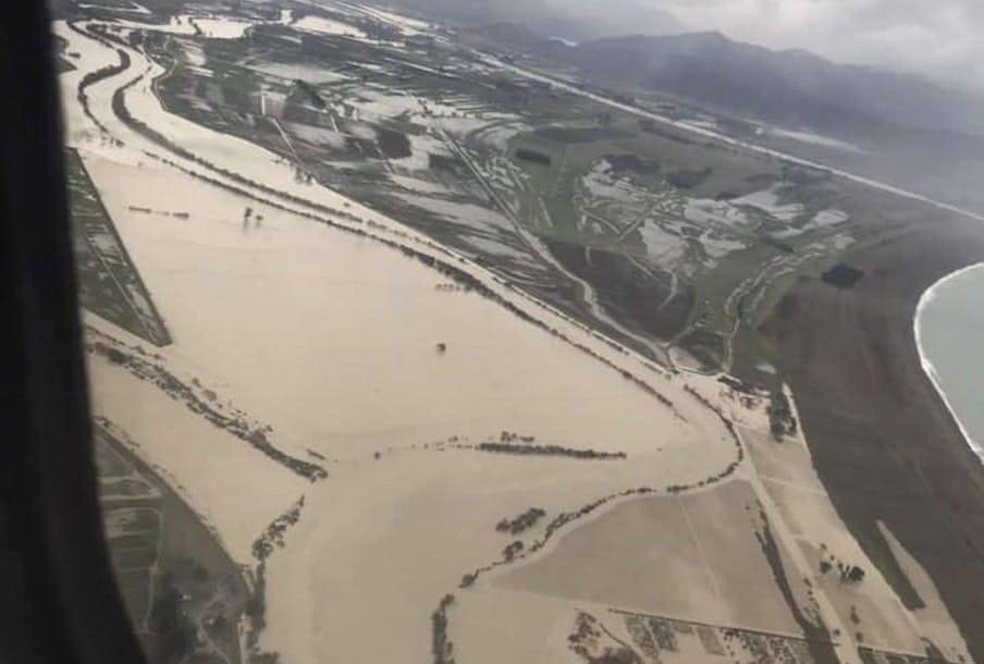
The Wairau River is nearing the upper limit of it's design parameters - flowing at 5973m3 per second. The upper limit is 6000m3.
SH6 Hira to Renwick, SH1 Picton to Spring Creek and SH63 Renwick to St Arnaud are all closed.
State Highway 1 closed amid bridge flood fear
Wairau River bridge has been closed amid safety fears as the river reaches 100-year-flood level.
Police are stopping traffic on State Highway 1 between Blenheim and Picton as floodwaters flow onto the road.
Marlborough District Council floodwatch shows the river has reached the floodway design capacity of between 5500m3 and 6000m3 per second.
The road between Picton and Tuamarina is also closed due to surface flooding, with reports of sinkholes.
A state of emergency was declared by deputy mayor Nadine Taylor at 12.20pm.
Renwick residents evacuated
Residents have been evacuated from their homes in Renwick.
The stop bank at Conders Bend began to over top threatening households in the lower terrace of Renwick.
221 properties of the Lower Terrace in Renwick were successfully evacuated.
The streets affected include Alma Street North, Gee Street, Blicks Road, Brook Street North, Inkerman Street North, Oudenarde Street and Terrace Road.
Bartlett’s Creek bridge, 20km up the Northbank Road from Renwick, has been washed out so access to the Northbank area, west of SH6 is now not possible.
There are about 25 rural properties are cut off.
Wairau River levels upstream of the Waihopai/Wairau rivers’ confluence have already peaked and are starting to reduce.
Roads are closed as heavy rain causes issues across Marlborough with rain continuing to fall.
State Highway 63 from west of Renwick has been closed with Canvastown and Havelock almost cut off by flood waters.
Marlborough District Council bosses are advising people to stay home and not travel unless “absolutely necessary.”
Rain levels continue to rise, with 37.1mm recorded in Blenheim town centre already today.
Awatere has also been hit hard with 111.5mm recorded at Awapiri today and 164.5mm at Onamalutu’s Bartlett Creek Saddle.
Residents in Wairau Valley are also being advised to boil their water.
Staff at Marlborough Lines are currently dealing with several weather related outages. Crews are out trying to restore power to affected areas in: Renwick, Crail Bay, Northbank Road and Kaituna.
Journey Manager for Waka Kotahi NZ Transport Agency Tresca Forrester is asking people to avoid travelling in affected areas as rain may close more roads as river levels peak.
“Our crews are working as hard as they can but these slips and debris will take time to clean up and flood waters take time to subside.
In some places we have to wait until the river levels have subsided to get access to the slips.
Please do not drive if you do not have to or delay your journey until later today and check highways then.”
If residents are worried about potential flooding of property, call council on 03 520 7400.
Wairau Valley township residents are advised to boil their water.
Roads closed – as at 8.30 am this morning
- All State Highway 63 from west of Renwick
- Queen Charlotte Drive - the whole road
- Kaiuma Bay Rd due to a slip
- Duncan Bay Rd due to a tree down blocking road
- Para Rd (whole road) due to flooding
- Chaytors/Wairau Bar Rd ferry bridge due to flooding
- Northbank Road at Onamalutu due to trees down
- Awatere Valley Rd east of fords due to a slip
- Hammerichs Rd due to a tree down
- Inkerman St due to flooding
- Moenui Road
- Waihopai Road
- Dunbeath St off Kinross St

